This chart shows the number of charities that have a specific local geographical focus. It shows how many charities seek to benefit causes in the legacy district areas of Aylesbury Vale, Chiltern, Wycombe and South Buckinghamshire – as well as Buckinghamshire as a whole.
According to the available data, there are 607 charities operating in Aylesbury Vale, 436 charities operating in Wycombe, 356 charities focusing on causes in the Chilterns and 171 charities focusing on South Buckinghamshire.
This data was collected by Community Impact Bucks for their State of the Sector 2019 report. It used source data from the Charity Commission’s register of charities. Community Impact Bucks published a methodology report explaining how they undertook the analysis and calculated their findings.
Charity Commission data was matched by postcode to the District Council areas that existed in 2019. Using this approach, 2,402 charities with a Buckinghamshire focus were identified, although there might be other charities working to benefit Buckinghamshire who were not identified this way.
It is also worth noting that there are more voluntary and community sector organisations working in Buckinghamshire who are not registered charities, and who are not included in the data below.
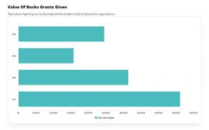
Geographic Local Charity Focus
Number of charities focusing on each geographical area
No Data Found